France Around c.1430
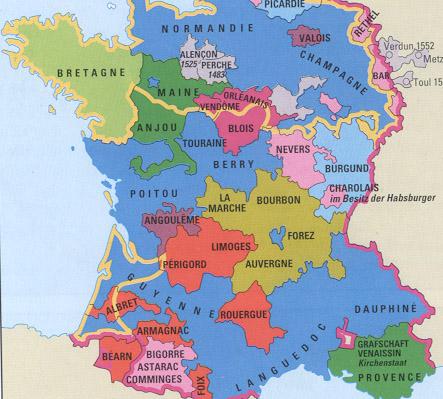
The above map shows the fragmentation of France
prior to 1430. Only the territories colored in blue were under
the French kings, and until 1429, English troops occupied the
north, west, and southwest (areas outlined in gold). Many
other regions, such as the Bourbon Duchy, were independent of
the French crown.
By 1453, however, Charles XII had driven the
English out of France, and his successors annexed
Burgundy in 1477, Anjou and Provence in 1481 and Brittany in 1491.
|
Wanna find bargains?
|
|
WAREHOUSE.COM is a division of MicroWarehouse,
Inc.—a $2.2 billion dollar reseller and publisher of one of the top grossing direct mail catalogs worldwide.
Click the above logo to visit our home page or you can search for the best price of our PC, Mac and Data Communication products below: |


